


How UAS/Drones Are Used In The Real Estate Industry

UAS/Drone Use In Real Estate | Ace of Drones
From Aerial Imagery to Actionable Property Intelligence
Real estate has always been about location.
But understanding a property requires considerably more than knowing its address.
Owners, investors, developers, brokers, property managers, engineers, inspectors, lenders, and other stakeholders need information about the property itself, its improvements, surrounding conditions, access, infrastructure, development potential, condition, and changes over time.

Professional Unmanned Aircraft Systems (UAS) can provide an entirely different perspective on that information.
Modern drones equipped with high-resolution RGB cameras, thermal sensors, positioning systems, LiDAR, and other specialized payloads can collect visual and geospatial information that supports activities throughout the real estate lifecycle—from initial property evaluation and acquisition through planning, development, marketing, management, inspection, capital improvements, and eventual disposition.
The opportunity extends far beyond aerial photography.
A professionally planned UAS mission can create:
High-resolution aerial imagery
Property overview imagery
Orthomosaics
Topographic information
Elevation models
Contours
Point clouds
3D models
Roof and building-envelope imagery
Thermal information
Site-condition documentation
Progress documentation
Measurements
Change-detection products
Asset records
Marketing imagery
Georeferenced property information
The value is not simply having a drone photograph a property.
The value comes from determining what information is needed, how accurately it must be collected, how it should be processed, and how the resulting data can support a real estate decision.
At Ace of Drones Technologies, we approach UAS operations as a data workflow:
PLAN → CAPTURE → PROCESS → ANALYZE → REPORT → INTEGRATE → REPEAT
The aircraft is the collection platform.
The data is the deliverable.
And the information derived from that data is what can help real estate professionals better understand properties, communicate conditions, evaluate opportunities, manage assets, and make better-informed decisions.
Core Benefits of UAS/Drones in Real Estate
Professional UAS data can support many different functions throughout the real estate lifecycle.

Depending on the property, mission, sensor, required accuracy, and intended use, UAS programs can help real estate organizations:
Capture current property conditions
Create compelling aerial marketing imagery
Provide broader site context
Document roofs and exterior building components
Inspect difficult-to-access areas
Support thermal investigations
Map large properties efficiently
Create orthomosaics and site maps
Generate point clouds and 3D models
Document construction and capital improvements
Monitor development progress
Evaluate surrounding land conditions
Document drainage and visible site conditions
Support property planning
Improve investor and owner communication
Create repeatable property records
Monitor changes over time
Support portfolio-level asset documentation
Integrate property information into GIS, CAD, BIM, and asset-management systems
Preserve historical property conditions
The greatest value often emerges when these capabilities are connected.
A drone can initially document a property being considered for acquisition. Later, another mission can support planning or inspection. During redevelopment, repeat missions can document construction. After completion, the same technology can support marketing, property management, inspection, capital planning, and long-term asset documentation.
A single flight creates a snapshot.
A repeatable UAS program can create a visual and geospatial history of a real estate asset.
1. Real Estate Sales and Property Marketing
Aerial photography is one of the most visible applications of drones in real estate—but professional UAS marketing can provide considerably more than an attractive overhead photograph.

Traditional ground photography is excellent for documenting interiors and individual exterior features, but it can be difficult to communicate the overall relationship between the building, land, improvements, access, surrounding properties, amenities, and neighborhood.
Aerial imagery provides context.
For residential properties, UAS imagery may help illustrate:
Property layout
Home and lot relationship
Acreage
Landscaping
Pools
Detached structures
Driveways
Outdoor living areas
Waterfront access
Adjacent open space
Neighborhood characteristics
Nearby amenities
For larger commercial or investment properties, aerial imagery can communicate information that may be difficult to understand from ground-level photographs alone:
Building configuration
Parking areas
Vehicle circulation
Loading areas
Access points
Adjacent roadways
Development areas
Outdoor storage
Tenant areas
Surrounding development
Nearby infrastructure
Video can add another dimension by creating a visual journey through and around the property.
But effective real estate UAS imagery should do more than look impressive.
It should help the viewer understand the property.
2. Real Estate Investing and Property Acquisition
Real estate investors make decisions based on information.
Before acquiring a property, an investor may want to understand the building, land, site configuration, surrounding development, access, visible conditions, improvement opportunities, and potential liabilities.

UAS provides a broad overhead perspective that can supplement traditional due diligence.
Potential areas of documentation may include:
Building configuration
Roof conditions
Parking
Access
Drainage
Surface conditions
Landscaping
Adjacent properties
Nearby development
Vacant land
Exterior improvements
Visible infrastructure
Signs of deferred maintenance
Storm-related damage
Construction activity
This does not replace professional property inspections, surveys, engineering evaluations, environmental assessments, appraisals, title work, or other specialized due-diligence services.
Instead, UAS can provide another information layer.
An investor reviewing multiple properties may be able to examine standardized aerial information for each asset before deciding where additional investigation is warranted.
This is especially valuable when properties are geographically dispersed.
The objective is not simply:
“What does this property look like?”
The more valuable question is:
“What information about this property could affect the investment decision?”
3. Commercial Real Estate
Commercial real estate is particularly well suited for professional UAS data collection because commercial properties frequently combine large buildings, extensive roofs, parking areas, infrastructure, exterior equipment, landscaping, access points, and multiple operational areas.
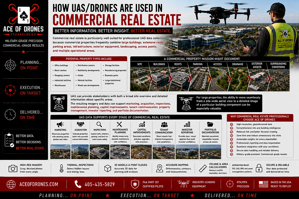
Potential property types include:
Office buildings
Retail centers
Shopping centers
Industrial facilities
Warehouses
Distribution centers
Multifamily developments
Hotels
Medical facilities
Mixed-use developments
Storage facilities
Manufacturing properties
Business parks
Large institutional properties
UAS can provide stakeholders with both a broad site overview and detailed information about specific areas.
A commercial property mission might document:
SITE → BUILDINGS → ROOFS → PARKING → ACCESS → DRAINAGE →
EXTERIOR ASSETS → SURROUNDING CONDITIONS
The resulting imagery and data can support marketing, acquisition, inspections, maintenance planning, capital improvements, tenant communication, property management, investor reporting, and portfolio documentation.
For large properties, the ability to move seamlessly from a site-wide aerial view to a detailed image of a particular building component can be especially valuable.
4. Commercial Roof Inspections
Commercial roofs can represent a significant component of a property's condition, maintenance requirements, and capital expenditures.

They can also be large, complex, elevated, and difficult to document comprehensively from ground level.
High-resolution UAS imagery can provide detailed visual information about visible roof components such as:
Membrane conditions
Flashing
Penetrations
Rooftop equipment
Drainage components
Gutters
Parapets
Coping
Mechanical equipment
Solar installations
Visible damage
Debris
Ponding indicators
Previous repair areas
Storm impacts
UAS imagery can help qualified professionals identify areas warranting closer investigation without requiring every initial observation to involve physical roof access.
That distinction is important.
A drone does not replace a qualified roof inspector.
It provides another method of obtaining information.
5. Building-Envelope and Exterior Inspections

Buildings have many exterior components that may be difficult to examine from ground level.
Potential UAS inspection targets include:
Façades
Exterior walls
Windows
Sealants
Roof edges
Parapets
Balconies
Exterior cladding
Structural components
Elevated mechanical systems
Signage
Drainage components
Difficult-to-access architectural features
High-resolution imagery can provide a systematic visual record of these areas.
For property managers and owners, this can be useful when establishing baseline conditions, planning maintenance, investigating reported issues, documenting storm damage, or comparing changes between inspection periods.
Instead of relying only on isolated ground photographs, UAS imagery can create a more comprehensive visual record of the building exterior.
6. Thermal Inspection
Thermal sensors provide another layer of information by representing apparent surface-temperature differences.

Depending on the property, construction materials, environmental conditions, operating conditions, sensor capability, inspection methodology, and intended application, thermal UAS information may help qualified professionals investigate unusual temperature patterns associated with:
Roof systems
Building envelopes
Insulation irregularities
Moisture-related conditions
Mechanical equipment
Electrical components
Solar installations
Other areas where temperature differences may be meaningful
However, thermal imagery requires careful interpretation.
A thermal anomaly is not automatically a diagnosis.
It identifies an apparent temperature difference.
Sun exposure, wind, precipitation, emissivity, reflections, building materials, viewing angle, HVAC operation, sensor settings, and numerous other factors can influence thermal observations.
Professional thermal work therefore requires appropriate collection methodology, contextual interpretation, and physical verification when required.
7. Real Estate Management and Property Management
Property managers are responsible for understanding what is happening across the properties under their control.

That becomes increasingly difficult as properties become larger, more complex, or geographically dispersed.
UAS can help create a current visual record of:
Roofs
Building exteriors
Parking areas
Pavement
Landscaping
Drainage
Stormwater infrastructure
Exterior equipment
Signage
Lighting
Access areas
Construction
Maintenance activity
Vacant areas
Tenant improvements
Surrounding conditions
This can provide property managers with a common visual reference for discussions with owners, tenants, contractors, maintenance personnel, insurers, engineers, and other stakeholders.
Rather than relying exclusively on written descriptions such as:
“There appears to be deterioration near the northeast parking area.”
A georeferenced image can show the location, surrounding conditions, and relationship to the rest of the property.
That context can improve communication.
8. Repeatable Property Inspections

One of the most powerful applications of UAS in real estate is repeatability.
Properties can be captured:
Monthly
Quarterly
Semi-annually
Annually
Before acquisition
After acquisition
Before construction
During construction
After capital improvements
Before lease commencement
After major maintenance
Following severe weather
Before disposition
At predetermined inspection milestones
Whenever practical, repeat missions can use similar:
Flight routes
Altitudes
Camera settings
Sensor configurations
Coordinate systems
Ground-control methodology
Processing methods
File naming
Reporting standards
Deliverable formats
A property record might develop as:
BASELINE → PERIODIC INSPECTIONS → CHANGE DETECTION → INVESTIGATION → MAINTENANCE → VERIFICATION → REPEAT
The result is much more valuable than a collection of unrelated photographs.
A property manager can return to earlier conditions.
An owner can review how an asset has changed.
An investor can compare the condition at acquisition with the condition several years later.
One flight creates a snapshot. A repeatable UAS program creates history.
This mirrors the repeatable inspection philosophy in your Oil & Gas template, where consistency makes datasets collected months or years apart more useful for comparison.
9. Real Estate Planning and Site Evaluation
Before land is purchased, developed, expanded, or redeveloped, stakeholders need to understand the site.

UAS can provide a high-resolution overview of visible existing conditions.
Potential observations include:
Terrain
Existing buildings
Roads
Access
Vegetation
Drainage
Water features
Adjacent development
Utility corridors
Existing improvements
Surface conditions
Property relationships
Potential development areas
Orthomosaics and other geospatial products can provide a common visual reference during early discussions among developers, planners, engineers, architects, owners, and other stakeholders.
Instead of beginning with an abstract representation alone, project teams can examine a current aerial representation of the physical property.
Better understanding of existing conditions can support better planning discussions.
10. Topographic Mapping, Elevation Models and Contours
UAS photogrammetry can transform overlapping aerial imagery into geospatial products containing considerably more information than individual photographs.

Depending on project specifications, positioning methodology, control, processing, and accuracy requirements, deliverables may include:
Orthomosaics
Digital Surface Models
Digital Terrain Models
Elevation information
,Contours
Point clouds
3D models
Site maps
Surface measurements
Volumetric calculations
These products can support qualified professionals working in planning, engineering, architecture, construction, development, GIS, CAD, and other technical disciplines.
But the critical issue is accuracy.
A map that looks precise is not necessarily accurate.
If the information will support engineering, surveying, design, or other accuracy-dependent applications, the required accuracy should be established before the mission is designed.
The collection methodology should then be selected to satisfy that requirement.
11. RTK/PPK and Precision Positioning
Professional mapping missions may incorporate Real-Time Kinematic (RTK) or Post-Processed Kinematic (PPK) positioning.

Depending on the project, these workflows may be combined with:
GNSS
Ground Control Points
Checkpoints
Survey control
Known coordinate systems
Appropriate vertical datums
Accuracy verification
This becomes important when UAS information must align with existing:
GIS data
CAD drawings
Engineering information
Survey information
Site plans
Development plans
Asset records
The objective is not simply to identify where something appears in an aerial photograph.
The more useful question is:
“Where is this feature within the property's spatial information environment?”
12. Real Estate Development and Construction Monitoring
Real estate development changes a property continuously.
A vacant site becomes an active construction project.
Earthwork changes terrain.
Roads appear.
Utilities are installed.
Foundations are constructed.
Buildings rise.
Parking and landscaping are completed.
Professional UAS missions can document that transformation from beginning to end.
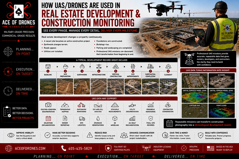
A typical development record might include:
BASELINE → SITE PREPARATION → EARTHWORK → INFRASTRUCTURE → VERTICAL CONSTRUCTION → SITE IMPROVEMENTS → SUBSTANTIAL COMPLETION → CLOSEOUT
UAS data may support:
Existing-condition documentation
Topographic mapping
Earthwork monitoring
Cut-and-fill analysis
Stockpile measurements
Utility documentation
Progress monitoring
Contractor coordination
Milestone documentation
Owner reporting
Site logistics
Drainage observations
3D modeling
As-built documentation
Final site records
Repeatable missions can transform construction photography into a chronological development record.
13. Documenting Conditions Before They Disappear
Some of the most valuable property information exists only temporarily.
A trench is open.
Utilities are installed.
Drainage infrastructure is visible.
A foundation is exposed.
Reinforcement is installed.
Concrete is placed.
The trench is backfilled.
Final grading occurs.
The landscaping is installed.
And the previous condition disappears.

Strategically scheduled UAS missions can document visible conditions before they are covered or altered.
Potential targets include:
Open trenches
Underground utility installation
Drainage infrastructure
Conduit
Foundations
Reinforcement
Pre-pour conditions
Excavations
Road construction
Site utilities
Parking construction
Restoration activities
When appropriately georeferenced, organized, and retained, this information may later support maintenance, renovations, future excavation, project closeout, warranty questions, capital planning, or other property-management requirements.
14. 3D Modeling and Point Clouds
Photogrammetric processing can convert overlapping aerial imagery into dense point clouds containing millions of spatially positioned points.

Those points can represent visible:
Terrain
Buildings
Roofs
Roads
Parking areas
Excavations
Landscaping
Structures
Site improvements
Surrounding property conditions
These datasets can then support 3D representations of the property.
Potential uses include:
Property visualization
Development planning
Construction review
Remote collaboration
Investor communication
Site planning
Appropriate measurements
Asset documentation
Change detection
Historical documentation
Digital Twin initiatives
For large commercial assets, developments, and portfolios, 3D models can help stakeholders who are not physically present gain a much stronger spatial understanding of the property.
Repeated 3D captures can progressively create a digital history of how an asset changes.
15. Real Estate Portfolio Management
The value of UAS becomes especially interesting when an owner or investor manages multiple properties.

A single property can produce substantial information.
A portfolio can produce thousands of photographs, inspection records, maps, models, maintenance observations, construction records, and historical datasets.
Without standardization, that information can quickly become fragmented.
A professional portfolio-level UAS program can establish consistent methods for:
Property identification
Mission scheduling
Image collection
Inspection areas
Coordinate systems
File naming
Data organization
Reporting
Deliverable formats
Historical comparison
Data retention
This can help create a more consistent information environment across geographically dispersed assets.
Imagine an investment portfolio where every property has a standardized digital record containing:
PROPERTY OVERVIEW → CURRENT CONDITION → ROOF → EXTERIOR → SITE →
CAPITAL PROJECTS → HISTORICAL CAPTURES → REPORTS
That creates the potential for decision-makers to evaluate individual properties while maintaining a consistent portfolio-wide information structure.
16. Capital Planning and Maintenance
Real estate assets require continuous investment.
Roofs age.
Parking surfaces deteriorate.
Drainage systems require attention.
Exterior components weather.
Mechanical equipment changes.
Landscaping grows.
Storms cause damage.
Capital improvements alter the property.
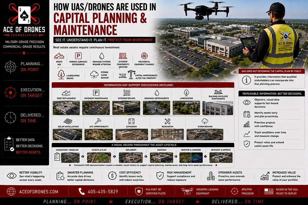
Repeatable UAS documentation can help owners and property managers establish a visual record of those changes.
Information may support discussions involving:
Roof replacement
Pavement maintenance
Exterior repairs
Drainage improvements
Landscaping
Building-envelope maintenance
Solar installations
Site improvements
Expansion
Renovation
Storm repairs
UAS does not determine the capital plan by itself.
It provides information that qualified stakeholders can incorporate into that planning process.
17. Insurance, Storm Damage and Risk Documentation
Severe weather can change property conditions quickly.
Wind, hail, tornadoes, flooding, wildfire, and other events can affect buildings and land across large areas.

Where legally and operationally appropriate, UAS may help document:
Roof conditions
Exterior damage
Debris
Flooding
Drainage
Standing water
Access limitations
Damaged structures
Surrounding terrain
Vegetation damage
Site-wide impacts
Aerial imagery can be particularly valuable for understanding the extent and geographic context of an event.
It can supplement ground inspections by helping qualified personnel identify areas where closer investigation may be warranted.
Pre-event documentation can also be valuable.
A well-organized historical property record provides a reference showing observable conditions before an event occurred.
18. GIS, CAD, BIM and Asset-Management Integration
Drone data becomes significantly more valuable when it fits into systems the real estate organization already uses.

Depending on client requirements, UAS-derived information may support:
GIS
CAD
BIM
Property-management systems
Asset-management platforms
Common Data Environments
Mapping platforms
Inspection databases
Maintenance systems
Construction-management platforms
Digital Twin initiatives
Enterprise data systems
Before the aircraft launches, important questions should be answered:
What information is required?
Who will use it?
What decision will it support?
What accuracy is required?
What coordinate system applies?
Which software will receive the information?
Which file formats are required?
How frequently should the property be captured?
How should revisions be managed?
How long should the information be retained?
The objective should not be to create another isolated folder full of drone photographs.
Don't make the real estate organization adapt to the drone data.
Design the drone-data workflow to support the organization.
This follows the same workflow-integration principle established in your Oil & Gas blog.
19. Data Organization and Professional Reporting
Raw imagery is only the beginning.

A professional real estate UAS data package may include:
Property identification
Mission date
Flight information
Mission methodology
Aircraft information
Sensor information
Coordinate-system documentation
Ground-control information
Accuracy assessments
Georeferenced imagery
Marketing imagery
Inspection imagery
Orthomosaics
Elevation models
Point clouds
3D models
Thermal imagery
Annotated observations
Measurements
Change-detection products
Data indexes
Metadata
Professional reports
Another qualified stakeholder should be able to determine:
What was collected?
When was it collected?
Where was it collected?
Why was it collected?
How was it collected?
Which aircraft and sensor were used?
Which coordinate system applies?
What accuracy was required?
How was the information processed?
What has changed?
Which files represent the final deliverables?
Consistent naming, metadata, mission identifiers, property identifiers, version control, coordinate documentation, and report organization become increasingly important as the same asset is captured repeatedly.
That is the difference between delivering photographs and delivering a:
Professional Real Estate UAS Dataset
Your Oil & Gas template makes the same distinction: raw imagery is only the beginning, and a professional package preserves enough mission, sensor, coordinate, accuracy, processing, metadata, and deliverable information for another stakeholder to understand the dataset.
20. Data Ownership, Security and Chain of Custody
Real estate data can contain sensitive information.

Detailed aerial information may reveal:
Property layouts
Access points
Security features
Building configuration
Equipment
Infrastructure
Construction activity
Asset conditions
Tenant areas
Operational information
Professional data management should therefore address:
Data ownership
Authorized access
Original-image retention
Processed-data retention
Version control
Storage
Backup
Metadata preservation
Confidentiality
Secure transfer
Deliverable control
Chain of custody
Chain of custody can become especially important when imagery or data may later relate to an insurance matter, property dispute, contractual disagreement, warranty question, construction issue, damage claim, or legal proceeding.
Maintaining original files, timestamps, metadata, processing records, and controlled deliverables can help preserve the integrity of the property record.
Professional data deserves professional stewardship.
21. FAA Compliance and Property Coordination
Real estate UAS missions are aviation operations.

Professional mission planning may need to consider:
FAA Part 107 requirements
Airspace
Required authorizations
Temporary Flight Restrictions
Nearby airports and heliports
Visual line of sight
Weather
Buildings
Towers
Electrical infrastructure
Roads
Vehicles
Pedestrians
Tenants
Construction activity
Launch and recovery locations
Emergency procedures
Property-specific safety requirements
Urban and commercial properties can present particularly complex environments because people, traffic, buildings, utilities, and nearby aviation activity may all affect mission planning.
A technically successful imagery mission that introduces unnecessary operational risk is not a successful mission.
Professional UAS operations require both:
Technical Expertise + Aviation Discipline
The safest and most useful mission is one that is coordinated with property operations rather than treated as an unrelated activity occurring overhead.
Who Benefits From UAS/Drone Real Estate Data?

Property Owners
Gain a current, comprehensive visual perspective of property conditions, improvements, maintenance issues, construction, and changes over time.
Real Estate Investors
Use aerial and geospatial information to supplement acquisition research, due diligence, asset monitoring, capital planning, and disposition decisions.
Real Estate Brokers and Sales Teams
Use professional aerial imagery and video to communicate property characteristics, location, scale, improvements, amenities, and surrounding context.
Commercial Real Estate Professionals
Gain broader visibility into large buildings, roofs, parking, access, exterior assets, site configuration, and surrounding conditions.
Property and Asset Managers
Maintain repeatable records of roofs, exteriors, parking areas, landscaping, drainage, capital improvements, and other property conditions.
Developers
Use appropriately specified UAS information to support site evaluation, planning, development documentation, construction monitoring, and project closeout.
Engineers, Architects, and Planning Teams
Use compatible mapping, imagery, point-cloud, elevation, and 3D information within appropriate technical workflows.
Construction Teams
Document existing conditions, earthwork, infrastructure, progress, quantities, milestones, and final site conditions.
GIS, CAD and BIM Teams
Integrate appropriately structured geospatial and reality-capture information into broader property and development information systems.
Facility and Maintenance Teams
Use detailed imagery to supplement maintenance planning and investigations of roofs, façades, exterior assets, drainage, pavement, and difficult-to-access areas.
Insurance and Risk Professionals
Use organized property documentation to supplement condition records, incident assessments, claims-related investigations, and risk-management workflows where appropriate.
Lenders and Investment Partners
Use current visual information to supplement progress reports, property reviews, construction documentation, and other asset-related information.
Turning Real Estate Activity Into Property Intelligence
Each UAS capability has value independently.
The greater opportunity emerges when those capabilities work together.

A drone can document a property before acquisition.
It can map the land.
It can inspect the roof.
It can document the building exterior.
It can create an orthomosaic.
It can generate a point cloud and 3D model.
It can document existing site conditions.
It can return during construction.
It can document infrastructure before it disappears.
It can monitor capital improvements.
It can create marketing imagery.
It can return after severe weather.
It can inspect the same property next year.
And it can preserve those datasets as part of a structured historical property record.
When missions are planned intentionally, collected consistently, processed appropriately, organized professionally, integrated into existing workflows, and retained securely, UAS becomes considerably more than an aerial-photography technology.
It becomes a property-information system.
The drone is the collection platform.
The data is the product.
The information gained from that data is the value.
That data-centric philosophy is central to the template you provided, which frames UAS as an information system rather than merely an aerial-imaging technology.
Why Partner With Ace of Drones for Real Estate UAS Data?
Choosing a real estate drone provider should involve much more than comparing aircraft specifications or finding someone who can take attractive aerial photographs.

Professional real estate UAS operations can require an understanding of:
Aviation
Operational safety
Mission planning
High-resolution imaging
GNSS
RTK/PPK
Mapping
Photogrammetry
Geospatial accuracy
Thermal imaging
Reality capture
Property inspection documentation
Construction documentation
Data organization
GIS/CAD/BIM integration
Reporting
Data security
Client workflows
Intended use of the final information
A beautiful aerial photograph that cannot answer the client's question has limited value.
A detailed map with unknown accuracy has limited value.
A sophisticated 3D model that cannot integrate into the client's workflow has limited value.
A thousand photographs without an organized method of finding, understanding, comparing, and using them can quickly become a data-management problem rather than a solution.
Ace of Drones approaches the mission from the opposite direction.
Before determining how to collect the data, we first determine what the data needs to accomplish.
We begin with questions:
What does the client need to know?
What decision will this information support?
What deliverable can answer that question?
What accuracy does that deliverable require?
Which sensor is appropriate?
What collection methodology is required?
How should the information be processed?
How should it integrate into the client's existing systems?
How should the information be organized?
How should it be secured, delivered, and retained?
Will the property need to be captured again?
How can today's dataset remain useful tomorrow?
Only after those questions are answered should the aircraft take off.
That is the difference between:
Drone Photography
and
Professional UAS Data Collection and Analysis
This preserves the mission-first approach in your existing blog: define the client question, required deliverable, accuracy, sensor, methodology, processing, integration, organization, security, and retention before launching the aircraft.
Better Data. Better Decisions. Better Real Estate.
The real estate industry does not need drones simply because drones are advanced technology.

It needs better information.
Information that is:
Current
Accurate
Measurable
Georeferenced
Repeatable
Comparable
Organized
Secure
Accessible
Actionable
When properly collected and integrated into real estate workflows, professional UAS data can help organizations understand properties more clearly, inspect more intelligently, market more effectively, document more consistently, monitor assets more efficiently, preserve historical information, and make better-informed decisions.
At Ace of Drones Technologies, we do not consider the aircraft itself to be the deliverable.
The data is the deliverable.
The aircraft is the tool used to collect it.
Our objective is to transform aerial observations into:
Accurate. Organized. Repeatable. Actionable Property Intelligence.
Every mission should answer a real estate question.
Every dataset should have a purpose.
Every deliverable should make it easier for real estate professionals to understand their properties, manage their assets, communicate with stakeholders, and make informed decisions.
Ace of Drones Technologies
Military-Grade Precision
Commercial-Grade Results
Planning... ON POINT
Execution... ON TARGET
Delivered... ON TIME


Comments