


How UAS/Drones Are Used In The Oil and Gas Industry

Updated: Sep 15
UAS/Drones Use in the Oil & Gas Industry | Ace of Drones
How UAS/Drone Data Is Used In The Oil and Gas Industry?
From Drone Imagery to Actionable Energy Intelligence
The oil and gas industry operates some of the most geographically dispersed, technically complex, environmentally sensitive, and safety-critical infrastructure in the world.
How Are UAS/Drones Used In the Oil and Gas Industry???

From well pads and gathering systems to pipelines, compressor stations, processing facilities, storage terminals, refineries, and rights-of-way, operators must continually understand the condition of assets spread across large areas—often in locations that are difficult, expensive, or hazardous to access.
Traditional inspections remain essential, but they can require personnel to walk long rights-of-way, climb elevated structures, enter difficult terrain, work near operating equipment, or coordinate aircraft and ground crews simply to obtain the information needed to make a decision.
Professional Unmanned Aircraft Systems (UAS) / Drones can change how that information is collected.
Modern drones equipped with high-resolution RGB cameras, thermal sensors, LiDAR, positioning systems, and specialized payloads can provide another layer of intelligence for inspection, mapping, monitoring, measurement, documentation, and asset-management workflows.
But the value is not simply the drone.
At Ace of Drones Technologies, we approach UAS operations as a data workflow:
PLAN → CAPTURE → PROCESS → ANALYZE → REPORT → INTEGRATE → REPEAT
The aircraft is the collection platform.
The data is the deliverable.
And the information derived from that data is what helps oil and gas professionals make better-informed decisions.
Core Benefits of UAS/Drones in Oil & Gas
Professional UAS programs can help oil and gas organizations:
Reduce unnecessary personnel exposure
Inspect difficult-to-access assets
Cover large geographic areas efficiently
Capture high-resolution visual information
Support thermal inspections
Map facilities and rights-of-way
Monitor pipelines and gathering systems
Document construction and maintenance
Monitor vegetation and encroachment
Support environmental programs
Document storm and disaster impacts
Create orthomosaics, point clouds, and 3D models
Improve asset documentation
Establish repeatable inspection records
Support maintenance planning
Improve communication between field and office personnel
Preserve historical site conditions
Integrate reality-capture information into GIS and asset-management systems

These capabilities become considerably more valuable when UAS missions are not treated as isolated flights.
A single flight provides information about a facility at a particular moment.
A repeatable UAS program can show how that facility changes over weeks, months, and years.
1. Pipeline and Right-of-Way Monitoring
Pipeline networks can extend for hundreds or thousands of miles across agricultural land, forests, wetlands, waterways, mountains, developed areas, and remote terrain.

That creates an enormous monitoring challenge.
UAS can provide detailed aerial information along selected pipeline corridors and rights-of-way, helping operators observe conditions that may warrant additional investigation.
Potential observations may include:
Vegetation encroachment
Erosion
Drainage changes
Washouts
Standing water
Exposed infrastructure
Construction activity
Unauthorized access
Right-of-way obstructions
Storm damage
Land disturbance
Changes near crossings
Encroaching development
Access-road conditions
High-resolution imagery also provides something particularly valuable:
context.
Rather than documenting only an individual feature from ground level, aerial imagery can show that feature in relation to the surrounding terrain, drainage, roads, vegetation, infrastructure, and property conditions.
When the same corridor is captured repeatedly, operators can begin comparing conditions over time rather than relying solely on isolated observations.
2. Facility and Asset Inspections
Oil and gas facilities contain equipment that can be elevated, congested, difficult to reach, or located near active operations.

Potential UAS inspection targets include:
Tanks
Tank roofs
Pipe racks
Flare structures
Towers
Stacks
Buildings
Roof systems
Elevated piping
Process equipment
Structural components
Compressor stations
Pump stations
Terminal infrastructure
Difficult-to-access exterior components
High-resolution optical sensors allow qualified personnel to review detailed imagery without requiring every initial observation to involve direct physical access.
This can be particularly useful for screening, documentation, maintenance planning, and determining where closer investigation is warranted.
UAS does not eliminate the need for qualified inspectors.
Instead, it can give those professionals another way to obtain information.
3. Thermal Inspection
Thermal imaging adds another layer of information by measuring patterns of emitted infrared energy and representing apparent surface-temperature differences.

Depending on the asset, operating conditions, environmental conditions, sensor capability, inspection methodology, and intended application, thermal UAS data may help qualified personnel investigate unusual temperature patterns associated with equipment or infrastructure.
Potential applications can include observations of:
Tanks
Process equipment
Electrical infrastructure
Mechanical equipment
Buildings and roofs
Insulation systems
Pipeline-related infrastructure
Solar systems supporting remote facilities
Other assets where temperature differences are meaningful
However, thermal imagery must be interpreted correctly.
A thermal anomaly is not automatically a diagnosis.
It indicates an apparent temperature difference.
Sunlight, wind, precipitation, surface materials, emissivity, reflections, viewing angle, operating conditions, sensor settings, and many other variables can affect thermal observations.
Professional thermal inspection therefore requires appropriate collection methodology, contextual interpretation, and physical verification when required.
4. Methane and Gas-Detection Applications
Specialized UAS platforms can carry sensors designed for certain atmospheric and gas-detection applications.
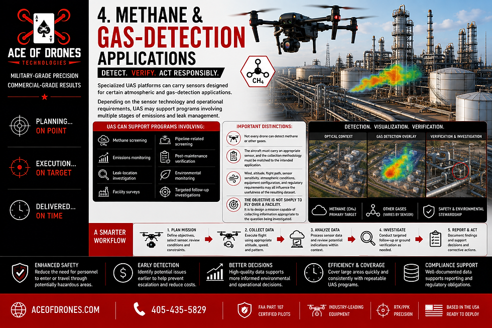
Depending on the sensor technology and operational requirements, UAS may support programs involving:
Methane screening
Emissions monitoring
Leak-location investigation
Facility surveys
Pipeline-related screening
Post-maintenance verification
Environmental monitoring
Targeted follow-up investigations
This is an important distinction because not every drone can detect methane or other gases.
The aircraft must carry an appropriate sensor, and the collection methodology must be matched to the intended application.
Wind, altitude, flight path, sensor sensitivity, atmospheric conditions, equipment configuration, and regulatory requirements may all influence the usefulness of the resulting dataset.
The objective is not simply to fly over a facility.
It is to design a mission capable of collecting information appropriate to the question being investigated.
5. Well Pad and Production-Site Monitoring

Well pads and production sites change throughout their operational lifecycle.
UAS can provide an overhead perspective useful for documenting:
Site layout
Equipment locations
Access roads
Drainage
Surface conditions
Material storage
Vegetation
Secondary containment
Construction activity
Maintenance activity
Surrounding land conditions
Changes over time
A georeferenced aerial record can provide field personnel, engineers, environmental teams, managers, and other stakeholders with a common visual reference.
Instead of describing conditions solely through photographs and written reports, teams can review the overall site and then examine specific areas in greater detail.
6. Construction and Capital Projects
Oil and gas organizations continually construct and modify infrastructure.
Projects may include pipelines, gathering systems, compressor stations, tank farms, processing facilities, access roads, containment systems, utility infrastructure, and facility expansions.

UAS can document these projects from pre-construction through final closeout.
A typical project lifecycle might include:
BASELINE → SITE PREPARATION → EARTHWORK → INSTALLATION → CONSTRUCTION → COMMISSIONING → AS-BUILT → CLOSEOUT
During construction, UAS data may support:
Existing-condition documentation
Topographic mapping
Earthwork monitoring
Cut-and-fill analysis
Stockpile measurements
Progress monitoring
Contractor coordination
Utility documentation
Pipeline construction documentation
Site-access planning
Drainage observations
Milestone documentation
As-built records
Final site documentation
Repeatable flights can turn construction imagery into a chronological project record.
7. Documenting Infrastructure Before It Disappears
Some of the most valuable construction information exists only temporarily.
A trench is excavated.
Pipe is installed.
Utilities are placed.
Connections are completed.
The trench is backfilled.
Final grading occurs.
And much of the physical evidence disappears.

Strategically scheduled UAS missions can document visible conditions before they are covered.
Potential documentation targets include:
Open trenches
Pipeline placement
Utility crossings
Conduit
Drainage infrastructure
Road crossings
Facility foundations
Site utilities
Excavations
Access improvements
Restoration activities
When properly georeferenced and organized, this historical information may later support maintenance planning, future excavation, project closeout, coordination, warranty investigations, or other operational requirements.
8. Topographic Mapping and Geospatial Data
UAS photogrammetry can transform overlapping aerial imagery into geospatial products that provide far more information than individual photographs.

Depending on project specifications, positioning methodology, ground control, processing, and accuracy requirements, deliverables may include:
Orthomosaics
Digital Surface Models
Digital Terrain Models
Contours
Point clouds
3D models
Elevation information
Site maps
Volumetric calculations
These products can support engineers, environmental teams, construction personnel, GIS professionals, planners, and other qualified stakeholders.
The critical issue is accuracy.
A map that looks precise is not necessarily accurate.
Professional geospatial UAS work should establish the required accuracy before collection begins and select the positioning, control, flight, sensor, and processing methodology accordingly.
9. RTK/PPK and Precision Positioning
Professional mapping missions may use Real-Time Kinematic (RTK) or Post-Processed Kinematic (PPK) positioning to improve the geospatial quality of collected information.

Depending on project requirements, these workflows may be combined with:
GNSS
Ground Control Points
Checkpoints
Survey control
Known coordinate systems
Appropriate geoid or vertical-datum information
Accuracy verification
This becomes particularly important when UAS information must align with existing engineering, GIS, CAD, survey, or asset-management information.
The objective is not simply:
“Where is this feature in the photograph?”
The more valuable question is:
“Where is this feature in the project's spatial information environment?”
10. Volumetric Analysis and Material Management
UAS-derived surface models can support volume calculations for appropriately visible materials and terrain.

Applications may include:
Aggregate stockpiles
Soil
Excavated material
Construction materials
Cut-and-fill quantities
Berms
Containment areas
Reclamation earthwork
Repeatable measurements can help teams understand how quantities change over time.
Rather than relying only on isolated field measurements, organizations can maintain a visual and quantitative record associated with each measurement period.
11. Environmental Monitoring
Oil and gas operations frequently interact with environmentally sensitive areas and regulatory requirements.

UAS can provide another data source for environmental professionals monitoring visible surface conditions.
Potential applications include:
Vegetation monitoring
Wetland documentation
Erosion monitoring
Drainage observations
Waterbody crossings
Restoration monitoring
Reclamation documentation
Habitat observations
Surface disturbance
Spill-area documentation
Stormwater conditions
Change detection
Repeated missions can be especially useful because environmental management is often about change over time.
A single dataset documents a condition.
Multiple comparable datasets can document a trend.
12. Emergency and Incident Response
When severe weather, flooding, wildfire, equipment failure, or another incident affects infrastructure, obtaining situational awareness quickly can be critical.

Where legally and operationally appropriate, UAS can help document:
Flooding
Storm damage
Erosion
Access limitations
Damaged infrastructure
Debris
Surrounding terrain
Facility conditions
Right-of-way impacts
Visible incident conditions
Aerial information can help decision-makers understand the extent and geographic context of an incident before sending personnel into every affected area.
This can improve prioritization and help teams determine where additional inspection resources may be required.
13. 3D Modeling and Point Clouds
Photogrammetric processing can convert overlapping imagery into dense point clouds containing millions of spatially positioned points.

Those points can represent visible:
Terrain
Tanks
Buildings
Roads
Pipe corridors
Excavations
Stockpiles
Structures
Facility components
Surrounding infrastructure
From these datasets, 3D representations of facilities and project areas can be developed.
Potential applications include:
Remote visualization
Engineering coordination
Construction review
Site planning
Asset documentation
Appropriate measurements
Change detection
Stakeholder communication
Historical documentation
Repeated 3D captures can progressively create a digital record of how an asset or facility changes.
14. GIS, CAD and Asset-Management Integration
Drone data becomes significantly more useful when it fits into the systems an organization already uses.

Depending on client requirements, UAS-derived information may support:
GIS
CAD
Engineering workflows
Asset-management platforms
Maintenance systems
Common Data Environments
Mapping platforms
Inspection databases
Enterprise data systems
Digital Twin initiatives
Before the aircraft launches, the project should establish questions such as:
What information is required?
Who will use it?
What decision will it support?
What accuracy is necessary?
What coordinate system applies?
Which software will receive the data?
Which file formats are required?
How frequently should information be collected?
How will revisions be controlled?
How long should the information be retained?
Don't make the organization adapt to the drone data.
Design the drone-data workflow to support the organization.
15. Repeatable Inspection and Monitoring Workflows
Repeatability can transform UAS from a one-time service into a long-term asset-information program.

Facilities and corridors may be captured:
Weekly
Monthly
Quarterly
Bi-annually
Annually
At major maintenance intervals
Before and after construction
Following severe weather
Following identified events
At predetermined inspection milestones
Whenever practical, repeated missions should maintain consistency in factors such as:
Flight routes
Altitudes
Sensor configurations
Camera settings
Coordinate systems
Ground-control methodology
Processing methods
File naming
Reporting standards
Deliverable formats
A monitoring record might develop as:
BASELINE → PERIODIC CAPTURES → CHANGE DETECTION → INVESTIGATION → CORRECTIVE ACTION → VERIFICATION → REPEAT
Consistency makes datasets captured months or years apart easier to compare.
One mission creates a snapshot.
A repeatable UAS program creates history.
16. Data Organization and Reporting
Raw imagery is only the beginning.

A professional oil and gas UAS data package may include:
Project and facility identification
Flight information
Mission methodology
Aircraft information
Sensor information
Coordinate-system documentation
Ground-control information
Accuracy assessments
Georeferenced imagery
Orthomosaics
Point clouds
Elevation models
3D models
Thermal imagery
Inspection imagery
Annotated observations
Change-detection products
Volume calculations
Data indexes
Metadata
Professional reports
Another qualified stakeholder should be able to determine:
What was collected
When it was collected
Where it was collected
Why it was collected?
How it was collected?
With which aircraft and sensor?
In which coordinate system?
To what required accuracy?
How it was processed?
What information has changed?
And which files represent the final deliverables?
That is the difference between delivering photographs and delivering a professional UAS dataset or deliverable.
17. Data Ownership, Security and Chain of Custody
Oil and gas datasets may contain sensitive information concerning infrastructure locations, facility layouts, equipment, access, operations, construction, security, and asset conditions.

Professional data management should therefore address:
Data ownership
Authorized access
Original-data retention
Processed-data retention
Version control
Storage
Backup
Metadata preservation
Confidentiality
Secure transfer
Deliverable control
Chain of custody
Chain of custody can become particularly important when information may later relate to an incident, insurance matter, contractual disagreement, regulatory issue, warranty question, environmental matter, or legal proceeding.
Maintaining original files, timestamps, metadata, processing records, and controlled deliverables helps preserve the integrity of the record.
Professional data deserves professional stewardship.
18. FAA Compliance and Operational Coordination
Oil and gas facilities present complex UAS operating environments.

Professional mission planning may need to consider:
FAA Part 107 requirements
Airspace
Required authorizations
Temporary Flight Restrictions
Nearby airports and heliports
Helicopter activity
Visual line of sight
Weather
Terrain
Towers and vertical obstructions
Electrical infrastructure
Active equipment
Vehicles
Personnel
Hazardous areas
Launch and recovery locations
Emergency procedures
Facility-specific safety requirements
A technically successful data-collection mission that introduces unnecessary operational risk is not a successful mission.
Professional UAS operations require both technical expertise and aviation discipline.
The safest and most useful mission is integrated into facility operations rather than treated as an unrelated activity occurring overhead.
Who Benefits From Oil & Gas UAS Data?

Operations Teams
Gain current visual information about facilities, corridors, access, and changing field conditions.
Pipeline Integrity Teams
Use aerial information to supplement right-of-way monitoring, documentation, and targeted investigations.
Engineers
Use appropriately specified mapping, point-cloud, imagery, and 3D information within compatible technical workflows.
Construction Teams
Document progress, earthwork, installation, infrastructure, quantities, and project milestones.
Inspection and Maintenance Teams
Gain detailed visual access to assets that may otherwise require specialized access.
Environmental Teams
Monitor visible land, vegetation, drainage, restoration, erosion, and other surface conditions.
GIS and Asset-Management Teams
Integrate appropriately structured geospatial information into broader enterprise datasets.
Drafting and CAD Teams
Providing accurate, structured geospatial information that Drafters and CAD operators can turn into impressive, enterprise datasets.
Management and Owners
Gain a clear visual understanding of geographically dispersed assets and project conditions.
Insurance and Risk Professionals
Use organized documentation to supplement condition records, incident assessments, and risk-management workflows where appropriate.
Turning Oil & Gas Activity Into Operational Intelligence

Each UAS capability has value independently.
The greater opportunity emerges when those capabilities work together.
A drone can map a proposed facility.
It can document baseline conditions.
It can monitor construction.
It can record infrastructure before it is covered.
It can inspect difficult-to-access assets.
It can monitor a pipeline right-of-way.
It can create thermal imagery.
It can build point clouds and 3D models.
It can document environmental conditions.
It can return after an incident.
It can capture the same asset again next quarter.
And it can preserve those datasets as part of a structured historical record.
When missions are planned intentionally, collected consistently, processed appropriately, organized professionally, integrated into existing workflows, and retained securely, UAS becomes more than an aerial-imaging technology.
It becomes an information system.
The drone is the collection platform.
The data is the product.
The information gained from that data is the value.
Why Partner With Ace of Drones for Oil & Gas UAS Data?
Choosing a drone provider should involve much more than comparing aircraft specifications or asking who can fly over a facility.

Professional oil and gas UAS operations can require an understanding of:
Aviation
Operational safety
Mission planning
GNSS
RTK/PPK
Mapping
Photogrammetry
Geospatial accuracy
Thermal imaging
Reality capture
Inspection documentation
Data organization
GIS integration
Reporting
Security
Client workflows
Intended use of the final information
A beautiful aerial photograph that cannot answer an operational question has limited value.
A detailed map with unknown accuracy has limited value.
A sophisticated 3D model that cannot integrate into the client's workflow has limited value.
Ace of Drones approaches the mission from the opposite direction.
Before determining how to collect the data, we first determine what the data needs to accomplish.
We begin with questions:
What does the client need to know?
What decision will this information support?
What deliverable can answer that question?
What accuracy does that deliverable require?
Which sensor is appropriate?
What collection methodology is required?
How should the information be processed?
How should it integrate into the client's existing systems?
How should it be organized, secured, delivered, and retained?
Only after those questions are answered should the aircraft take off.
That is the difference between drone photography and professional UAS data collection and analysis.
Better Data. Better Decisions. Better Energy Operations.
The oil and gas industry does not need drones simply because drones are advanced technology.

It needs better information.
Information that is:
Current
Accurate
Measurable
Georeferenced
Repeatable
Comparable
Organized
Secure
Accessible
Actionable
When properly collected and integrated into operational workflows, professional UAS data can help organizations inspect more intelligently, document more consistently, understand conditions more clearly, reduce unnecessary exposure, preserve historical information, and make better-informed decisions.
At Ace of Drones Technologies, we do not consider the aircraft itself to be the deliverable.
The data is the deliverable.
The aircraft is the tool used to collect it.
Our objective is to transform aerial observations into accurate, organized, repeatable, actionable intelligence.
Every mission should answer an operational question.
Every dataset should have a purpose.
Every deliverable should make it easier for professionals to understand their assets and make informed decisions.


Comments