


How UAS/Drones Are Used In The Land Development and Land Management

UAS/Drone Use In Land Development and Land Management
Ace of Drones | Oklahoma City

Land development and land management depend on accurate, current, and actionable information about the ground. Surveyors, developers, engineers, planners, contractors, agricultural operators, environmental professionals, municipalities, utilities, and property owners routinely need to understand what exists on a site, how the terrain is configured, what has changed, and what needs to happen next.
UAS/drone technology provides an efficient way to collect high-resolution aerial imagery and geospatial data across properties ranging from individual development parcels to large tracts of land.
At Ace of Drones, we provide professional aerial data collection, mapping, photogrammetry, modeling, and analysis designed to give land-development and land-management professionals a more complete understanding of their sites.
This page follows the organization and level of technical detail of the Inspection & Insurance template you supplied, including its progression from applications and benefits through deliverables, technical capabilities, repeatable workflows, data governance, compliance, integration, and the final Ace of Drones value proposition.
How Drones Are Used in Land Development & Land Management
UAS technology can support projects throughout the entire lifecycle of a property—from initial site investigation and planning through development, construction, operation, maintenance, and long-term land management.
Common applications include:
Existing-condition documentation
Aerial site reconnaissance
High-resolution orthomosaic mapping
Topographic data collection
Digital Surface Models (DSM)
Digital Terrain Models (DTM)
Point-cloud generation
Contour development
Cut-and-fill analysis
Earthwork and grading documentation
Stockpile measurements
Volumetric calculations
Drainage and watershed visualization
Erosion monitoring
Vegetation assessment
Right-of-way documentation
Utility-corridor mapping
Road and access-route documentation
Property-development progress monitoring
Construction progress documentation
Land-use documentation
Environmental monitoring
Agricultural land assessment
Stormwater-management documentation
GIS data collection
3D modeling
Digital Twin development
Change detection
Before-and-after comparisons
Long-term property-condition monitoring
High-resolution RGB imagery, GNSS/RTK positioning, photogrammetry, georeferenced orthomosaics, elevation models, point clouds, and 3D models can transform a drone flight into a comprehensive digital representation of a property.
The objective is not simply to produce attractive aerial photographs.
The objective is to create accurate, organized, geospatially referenced information that professionals can use to plan, measure, analyze, document, and manage land more effectively.
Core Benefits of Drones in Land Development & Land Management

Faster Site Data Collection
Large properties can require considerable time to inspect and document from the ground.
A properly planned UAS mission can collect hundreds or thousands of overlapping images across a project area while maintaining systematic coverage.
This allows large areas to be documented efficiently and creates a permanent visual and geospatial record of site conditions at the time of the flight.
For developers, engineers, contractors, planners, and land managers, faster data acquisition can mean faster access to the information needed to make decisions.
High-Resolution Site Visibility
Satellite imagery and conventional aerial imagery can provide useful context, but they may not provide the resolution or currency required for detailed project decisions.
Drone imagery can provide substantially greater visual detail and can be collected specifically for the property and project being evaluated.
High-resolution imagery can document:
Roads
Trails
Drainage channels
Ditches
Culverts
Buildings
Fences
Tree lines
Vegetation
Water features
Stockpiles
Excavations
Grading
Construction activity
Equipment
Site access
Surface conditions
Existing improvements
Instead of relying exclusively on older imagery, stakeholders can work from a current aerial representation of the property.
Better Understanding of Terrain
Terrain influences nearly every land-development decision.
Slope, elevation, drainage, access, vegetation, existing improvements, and surrounding land uses can affect planning and development.
Photogrammetric drone data can help create digital representations of terrain that allow professionals to visualize the property from perspectives that are difficult to obtain from ground observations alone.
Depending on project requirements and data-collection methodology, UAS-derived elevation information can support:
Terrain visualization
Slope analysis
Preliminary drainage evaluation
Grading analysis
Earthwork planning
Access planning
Site-layout evaluation
Construction planning
Improved Project Documentation
Land-development projects change continuously.
Clearing, grading, excavation, utilities, roads, drainage improvements, foundations, structures, landscaping, and other activities can substantially alter a site over relatively short periods.
Repeat drone flights create date-stamped visual records showing how the property changes.
This documentation can support:
Project meetings
Progress reports
Contractor coordination
Owner updates
Engineering review
Site documentation
Dispute resolution
Historical records
Before-and-after comparisons
Reduced Time in Difficult Terrain
Some properties contain steep slopes, dense vegetation, muddy conditions, drainage channels, construction hazards, water features, or other areas that are difficult to access efficiently.
UAS operations can reduce the amount of time personnel must spend traversing difficult terrain simply to obtain visual information.
Drones do not eliminate the need for ground investigation, conventional surveying, engineering analysis, or site verification.
Instead, they provide another data-collection platform that can help professionals determine where additional field investigation is necessary.
UAS/DRONE TECHNOLOGY USES AND DELIVERABLES

High-Resolution Aerial Imagery
High-resolution RGB sensors can capture detailed photographs across an entire property.
Images can be collected vertically for mapping and at oblique angles for additional site context.
These images can document existing conditions, construction activity, land-use patterns, drainage features, vegetation, roads, structures, and other site characteristics.
Georeferenced Orthomosaic Mapping
One of the most valuable UAS deliverables for land-development projects is a high-resolution orthomosaic.
Hundreds or thousands of overlapping photographs can be processed into a geometrically corrected aerial representation of the property.
Unlike an individual aerial photograph, an appropriately generated orthomosaic provides a consistent overhead view that can be incorporated into mapping and GIS workflows.
Orthomosaics can support:
Site planning
Existing-condition documentation
Feature identification
Construction planning
GIS overlays
Property-management records
Progress monitoring
Change detection
Engineering coordination
They can also provide a highly intuitive visual base map that allows stakeholders to understand the property without requiring specialized 3D software.
Topographic Data & Elevation Modeling
Photogrammetric processing can generate elevation information from overlapping drone imagery.
Depending on project specifications, terrain, vegetation, ground control, equipment, and processing methodology, deliverables may include:
Digital Surface Models
Digital Terrain Models
Elevation maps
Contours
Hillshade models
Slope maps
Point clouds
Surface profiles
Cross sections
These products can help engineers, planners, developers, and contractors better understand the physical characteristics of the property.
Important distinction: UAS mapping products do not automatically constitute a legal boundary survey or replace work that must be performed by a licensed professional land surveyor. Deliverables and accuracy requirements should be defined according to the intended use of the data.
3D Modeling & Digital Twins
Photogrammetry can transform overlapping aerial imagery into detailed three-dimensional representations of land, structures, roads, excavations, stockpiles, and other site features.
3D models allow stakeholders to examine a property interactively rather than relying exclusively on two-dimensional plans and photographs.
Potential applications include:
Site visualization
Development planning
Design coordination
Construction monitoring
Terrain analysis
Earthwork visualization
Existing-condition documentation
Remote project review
Before-and-after comparison
Long-term asset management
Repeated datasets can also form the foundation of a Digital Twin or historical digital representation of the property.
Point Clouds
Photogrammetric processing can produce dense three-dimensional point clouds containing large numbers of spatially referenced points.
Point clouds can represent:
Terrain
Structures
Roads
Stockpiles
Excavations
Drainage features
Vegetation surfaces
Construction features
These datasets can be incorporated into compatible CAD, GIS, engineering, surveying, and modeling workflows.
For many professional applications, the point cloud becomes the underlying geospatial dataset from which additional products are derived.
Cut-and-Fill Analysis
Earthwork can represent a significant portion of land-development costs.
Drone-derived surface models can support comparison between existing and proposed or previous surfaces to help qualified professionals evaluate where material has been removed or added.
Potential applications include:
Grading documentation
Excavation monitoring
Embankment monitoring
Earthwork progress
Site-balancing analysis
Contractor documentation
Construction planning
Repeat flights can provide a visual and quantitative record of how grading operations change the site over time.
Stockpile & Volumetric Measurements
Stockpiles can be difficult and time-consuming to measure using traditional methods, particularly when numerous piles are distributed across a large site.
Photogrammetric models can be used to calculate volumes for materials such as:
Soil
Sand
Gravel
Aggregate
Rock
Mulch
Construction materials
Repeat measurements can help organizations track inventory and material movement over time.
The required collection methodology and accuracy should always be matched to the business purpose of the measurement.
Drainage & Stormwater Documentation
Water movement is a critical consideration in land development and long-term land management.
High-resolution imagery and elevation data can help professionals visualize:
Drainage channels
Ditches
Culverts
Detention areas
Retention ponds
Low areas
Erosion
Sediment accumulation
Surface-water pathways
Stormwater infrastructure
Drone data can provide valuable site context for engineers and environmental professionals responsible for evaluating drainage and stormwater conditions.
It should not be treated as a substitute for professional hydrologic or hydraulic analysis where such analysis is required.
Erosion Monitoring
Erosion can affect construction sites, agricultural properties, drainage systems, slopes, streambanks, roads, and undeveloped land.
Repeat UAS missions can document changes in erosion patterns over time.
This can help land managers identify:
Expanding erosion areas
Gully development
Slope deterioration
Sediment movement
Drainage problems
Vegetation loss
Areas requiring stabilization
Because flights can be repeated from similar locations and flight plans, drone imagery is particularly valuable for change detection.
Vegetation & Land-Cover Documentation
High-resolution aerial imagery can provide a broad overview of vegetation patterns across a property.
Depending on sensors and project requirements, UAS data may support documentation of:
Tree coverage
Brush encroachment
Mowing conditions
Vegetation growth
Bare ground
Land-cover changes
Vegetation near infrastructure
Drainage obstruction
Right-of-way encroachment
Specialized multispectral sensors can provide additional information for agricultural, environmental, vegetation-health, and land-management applications when required.
Roads, Trails & Access Planning
Access is fundamental to development and land management.
Drone imagery can document existing roads, trails, gates, stream crossings, drainage features, and obstacles.
Orthomosaics and terrain models can provide useful context when professionals are evaluating potential:
Access roads
Construction entrances
Equipment routes
Utility corridors
Maintenance roads
Emergency-access routes
Trails
The ability to visualize an entire property from above can make relationships between terrain and access much easier to understand.
Right-of-Way & Utility Corridor Documentation
Linear infrastructure can extend across large areas and may be difficult to document efficiently from the ground.
UAS missions can support visual and geospatial documentation of:
Utility corridors
Pipelines
Transmission routes
Road corridors
Drainage easements
Rights-of-way
Vegetation encroachment
Access conditions
Repeat flights can also create a historical record of corridor conditions.
Construction & Development Progress Monitoring
Once land development begins, drone technology can continue supporting the project.
Scheduled flights can document:
Clearing
Grubbing
Excavation
Grading
Roads
Utilities
Drainage systems
Foundations
Structures
Material storage
Equipment activity
Landscaping
Final site conditions
The result is a visual project timeline showing the progression from undeveloped land to completed development.
Existing-Condition Documentation
Before work begins, a drone mission can establish a comprehensive visual baseline of the property.
Baseline documentation can include:
Existing terrain
Roads
Adjacent properties
Drainage
Structures
Vegetation
Fences
Utilities visible from the air
Construction access
Surface conditions
Existing disturbances
This information can become particularly valuable when questions later arise about what conditions existed before construction began.
Change Detection
One of the strongest advantages of repeatable drone mapping is the ability to compare datasets collected at different times.
For example:
Existing Conditions → Clearing → Rough Grading → Infrastructure → Vertical Construction → Final Development
Comparison of these datasets can help reveal:
Land-cover changes
Grading changes
New construction
Material movement
Drainage changes
Vegetation changes
Erosion
Site-access changes
Instead of relying only on memory or individual photographs, project stakeholders can maintain a systematic visual history.
Ace of Drones Technical Capabilities
GNSS, RTK & PPK Positioning
Professional UAS mapping platforms can incorporate:
GPS
GLONASS
Galileo
Multi-band GNSS
Real-Time Kinematic positioning
Post-Processed Kinematic workflows
Ground control and checkpoints where required
Precise image georeferencing

The Inspection & Insurance template similarly emphasizes multi-band GNSS, RTK/PPK workflows, and precise georeferencing as important when findings must be mapped, measured, revisited, or compared over time.
For land-development applications, positional accuracy is particularly important because mapping products may need to integrate with existing CAD, GIS, engineering, or survey datasets.
High-Resolution RGB Drone Sensors
Professional RGB cameras can capture detailed imagery for mapping, inspection, documentation, photogrammetry, and 3D modeling.

Successful photogrammetric data collection requires more than simply flying over a property.
Mission planning must consider factors such as:
Flight altitude
Ground Sample Distance
Front overlap
Side overlap
Camera orientation
Exposure
Flight speed
Sun angle
Shadows
Terrain
Vegetation
Ground control
Required accuracy
Final deliverables
The mission should be designed backward from the required deliverable.
Automated Mapping Missions
Repeatable grid and corridor missions allow an aircraft to collect imagery systematically.
Depending on the project, mission types can include:
Standard mapping grids
Cross-grid missions
Oblique imagery missions
Corridor mapping
Perimeter documentation
Structure-focused missions
Terrain-following missions where supported and appropriate
Standardized flight plans also improve repeatability when the same property is monitored over time.
Photogrammetric Processing
After the flight, overlapping photographs can be processed to reconstruct the project area digitally.
A typical workflow may include:
Mission Planning → Data Capture → Quality Control → Image Alignment → Point-Cloud Generation → Surface Reconstruction → Orthomosaic Generation → Elevation Products → Analysis → Delivery
Data quality begins in the field.
Poor imagery, inadequate overlap, motion blur, inappropriate flight altitude, excessive shadows, weak georeferencing, or incomplete coverage can affect downstream products.
For that reason, professional UAS mapping requires both disciplined flight operations and disciplined data processing.
Land Development Across the Property Lifecycle
Drone technology can support land-development decisions before, during, and after construction.

Site Acquisition & Due Diligence
Before acquiring or developing property, aerial imagery can help stakeholders gain a broader understanding of existing conditions.
Drone data can provide context regarding:
Terrain
Existing improvements
Vegetation
Access
Drainage
Adjacent development
Roads
Surface conditions
Visible constraints
Planning & Preliminary Design
Once a site moves into planning, current aerial and geospatial information can provide a common visual reference for developers, engineers, planners, architects, contractors, and owners.
Orthomosaics and 3D models can make complex properties easier to understand during planning discussions.
Site Preparation & Grading
During clearing and grading, repeat UAS missions can document site transformation and support earthwork visualization.
This creates a record of development activity while helping stakeholders monitor progress.
Infrastructure Development
Drone data can document the installation and development of:
Roads
Drainage systems
Utilities
Detention facilities
Site access
Building pads
Other infrastructure
Construction Monitoring
Once vertical construction begins, UAS imagery can continue documenting the overall site.
Aerial imagery can provide project stakeholders with a perspective that is difficult to obtain from ground photographs alone.
Project Completion
A final UAS mission can document completed site conditions and create an aerial record of the finished development.
Depending on requirements, final deliverables may include:
Orthomosaic imagery
3D models
Aerial photographs
Final site documentation
GIS-ready data
Comparison imagery
Long-Term Land Management
Drone technology remains useful after construction is complete.
Scheduled flights can support:
Property-condition monitoring
Vegetation management
Drainage observation
Erosion monitoring
Infrastructure inspection
Development expansion
Maintenance planning
Historical documentation
This transforms drone mapping from a one-time service into a long-term land intelligence system.
Repeatable Land-Management Workflows
One of the strongest advantages of UAS technology is the ability to return to the same property and collect comparable datasets.

The supplied template emphasizes the same principle: once an inspection area and methodology are established, future flights can reproduce similar perspectives and coverage.
For land management, repeated datasets can support:
Weekly, Monthly, Quarterly, Bi-Annually, and Annual development monitoring
Quarterly property reviews
Annual land assessments
Seasonal vegetation comparisons
Post-storm assessments
Erosion monitoring
Earthwork tracking
Infrastructure monitoring
Before-and-after analysis
Long-term change detection
Over time, the client develops a digital historical record of the property.
Land Data Organization & Reporting
Collecting aerial imagery is only the beginning.

Professional land-development data should be organized so stakeholders can quickly understand:
What area was mapped?
When was the data collected?
How was it collected?
What coordinate reference system was used?
What level of accuracy was required?
What deliverables were produced?
What has changed since the previous collection?
How can the information be integrated into the client's workflow?
Depending on project requirements, an Ace of Drones land-development data package can include:
Project summary
Flight information
Site information
Data-collection methodology
Equipment information
Coordinate-system information
Ground-control information
Checkpoint information
Accuracy documentation
High-resolution aerial imagery
Georeferenced orthomosaics
Point clouds
Digital Surface Models
Digital Terrain Models
Contours
3D models
Volumetric calculations
Cut-and-fill analysis
Annotated maps
GIS-ready datasets
Progress imagery
Comparison imagery
Data appendices
The goal is to transform raw aerial imagery into organized geospatial intelligence that professionals can actually use.
Data Ownership, Security & Chain of Custody
Land-development datasets may contain commercially valuable or sensitive information about a property, development project, infrastructure, or client operation.

For that reason, professional data management matters.
Project requirements can define:
File naming
Original-image retention
Processed-data retention
Access permissions
Storage requirements
Geospatial metadata
Image timestamps
Coordinate-system documentation
Processing records
Delivery formats
Chain-of-custody procedures
Client confidentiality
Your supplied template makes the same point for inspection data: clear data governance helps preserve the integrity and usefulness of professional UAS evidence.
Airspace Authorization, Compliance & Operations
Land-development sites may be located near:
Airports
Heliports
Military installations
Controlled airspace
Urban areas
Critical infrastructure
Roads
Construction operations
Populated areas
Ace of Drones plans commercial UAS operations around applicable FAA requirements and site-specific operating conditions.
Operational planning can include:
Airspace review
FAA authorization when required
Aircraft registration and identification requirements
Flight-area assessment
Altitude limitations
Visual-line-of-sight requirements
Site access
Weather evaluation
Takeoff and landing locations
Personnel safety
Public safety
Construction activity
Emergency procedures
Airspace and site review should occur before mobilization, helping prevent unnecessary project delays.
Pilot Certification & Internal Protocols
Professional data begins with professional flight operations.
Commercial UAS missions are conducted by appropriately certificated remote pilots in accordance with applicable FAA requirements.
Professional operations should incorporate:
Pre-flight planning
Aircraft inspections
Mission-specific checklists
Airspace verification
Weather evaluation
Site-hazard assessment
Equipment verification
GNSS/RTK preparation when applicable
Battery management
Emergency procedures
Data-quality checks
Post-flight documentation
As your Inspection & Insurance template emphasizes, successful professional UAS operations depend on more than the aircraft itself; disciplined mission planning and consistent data collection are fundamental.
Integrating Drone Data into Land Development Workflows
UAS data provides the greatest value when it integrates with the systems professionals already use.

Depending on client requirements and compatible formats, drone-derived information can support:
Geographic Information Systems
CAD environments
Civil engineering workflows
Surveying workflows
Construction-management platforms
Asset-management systems
Mapping platforms
Planning applications
3D visualization systems
Digital Twin environments
Property-management systems
The objective is not to create another isolated collection of drone photographs.
The objective is to provide usable data that fits into the client's existing technical and decision-making workflow.
Benefits for Developers, Engineers & Land Managers
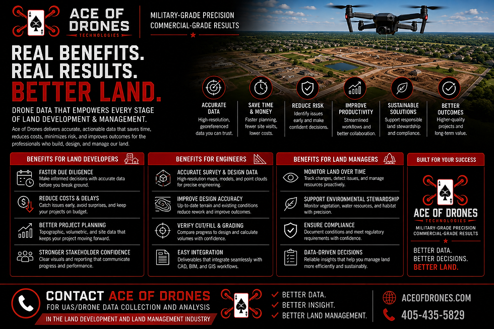
Better Site Intelligence
Current aerial imagery and geospatial data provide a more complete understanding of the property.
Faster Access to Information
Large areas can be documented efficiently, allowing project teams to obtain updated site information without relying exclusively on ground observations.
Better Communication
Aerial maps, photographs, and 3D models give multiple stakeholders a common visual reference.
Improved Documentation
Repeat flights create date-stamped records of project and property conditions.
Better Change Detection
Comparable datasets make it easier to understand how terrain, construction, vegetation, drainage, and infrastructure change over time.
Scalable Property Monitoring
The same standardized UAS methodology can be applied across individual sites, large properties, development portfolios, and geographically distributed assets.
Why Partner with Ace of Drones?
Land-development UAS work requires more than owning a drone.

It requires understanding aviation, geospatial data, photogrammetry, mapping, positioning, field operations, data quality, and the client's intended use of the final product.
Ace of Drones provides:
Professional UAS data collection
High-resolution RGB imagery
GNSS/RTK/PPK-capable workflows
Georeferenced aerial mapping
Orthomosaic production
Photogrammetric processing
Point-cloud generation
3D modeling
Digital Surface Models
Digital Terrain Models
Volumetric analysis
Progress monitoring
Change detection
GIS-oriented deliverables
FAA Part 107 commercial operations
Airspace planning and authorization management
Safety-focused operating procedures
Organized professional data delivery
Repeatable data-collection workflows
The technical capabilities emphasized in your original template—high-resolution imagery, RTK/PPK mapping, georeferenced data, photogrammetry, 3D modeling, FAA commercial operations, disciplined procedures, and structured deliverables—translate especially well to land-development and land-management applications.
Better Data. Better Planning. Better Land Management.
Drone technology gives land-development professionals something extremely valuable:
A current, detailed, measurable view of the property from above.
But the real value is not the drone.
It is the data.
It is knowing where that data came from, how it was collected, how accurately it represents the site, how it has changed over time, and how it can support better decisions.
At Ace of Drones, every mission begins with the same objective:
Collect the right data. Collect it safely. Collect it accurately. Organize it professionally. Deliver it in a form the client can actually use.
Whether the project involves an undeveloped parcel, commercial development, subdivision, construction site, agricultural property, utility corridor, large landholding, or long-term property-management program, UAS technology can provide a powerful new perspective on the land.
Ready to See Your Property from a Better Perspective?
Contact Ace of Drones for professional UAS/Drone Data Collection and Analysis for the Land Development and Land Management Industry.
Ace of Drones Technologies
MILITARY-GRADE PRECISION
COMMERCIAL-GRADE RESULTS
405-435-5829


Comments