


How UAS/Drone Technology Is Used In the Construction Industry

Updated: Aug 26
How UAS/Drones Are Used in Construction
Ace of Drones | Oklahoma City
Better Data. Better Visibility. Better Construction Outcomes.
Construction projects are constantly changing. Earthwork moves. Materials arrive and leave. Structures rise. Utilities disappear below grade. Subcontractors rotate through the site. Design revisions occur. Schedules tighten. Owners expect answers.
Project managers, engineers, superintendents, contractors, developers, lenders, and owners all need reliable information about what is actually happening in the field—not simply what was scheduled to happen.

UAS/drone technology provides a powerful way to capture that reality.
Modern drones equipped with high-resolution RGB cameras, RTK/PPK positioning, thermal sensors, LiDAR, and photogrammetric capabilities can transform a construction site into a measurable, repeatable digital dataset.
Construction teams can use professionally collected UAS data to support:
Existing-condition documentation
Site mapping and orthomosaics
Topographic data collection
Earthwork and grading analysis
Cut-and-fill calculations
Stockpile measurements
Progress monitoring
Change detection
3D modeling and point clouds
Structural and building-envelope inspections
Thermal inspections
Site logistics and coordination
BIM integration
Digital Twin development
As-built and closeout documentation
Owner, lender, and stakeholder reporting
At Ace of Drones, our objective is not simply to fly over a construction site and take pictures.
Our objective is to collect the right data, at the right time, with the right methodology, and transform that data into organized information construction professionals can actually use.
How UAS/Drones Are Used in Construction
UAS technology has evolved far beyond basic aerial photography. On a modern construction project, a drone can function as a sophisticated remote-sensing, reality-capture, and geospatial data-collection platform.

A properly planned mission can collect hundreds or thousands of overlapping images across a project site. Depending on the aircraft, sensor, positioning methodology, ground control, processing workflow, and required accuracy, those images can be transformed into:
High-resolution orthomosaics
Digital Surface Models
Digital Terrain Models
Elevation information
Point clouds
3D models
Cut-and-fill analyses
Stockpile volumes
Inspection imagery
Progress comparisons
Change-detection products
Annotated project maps
BIM-compatible reality-capture data
The real advantage is context.
Traditional construction photography often consists of individual ground-level photographs. Those photographs are valuable, but they may make it difficult to understand how one condition relates to the rest of the project.
Aerial information allows construction professionals to view buildings, roads, utilities, excavations, stockpiles, equipment, drainage, staging areas, access routes, and active work zones together.
One drone mission provides a snapshot.
A series of consistently collected missions creates a digital record of how the project changes over time.
We are not simply collecting aerial photographs. We are building organized datasets that can support construction decisions throughout the project lifecycle.
Core Benefits of UAS/Drones in Construction

Professional drone data can help construction teams:
Capture site information faster
Improve overall project visibility
Reduce unnecessary field exposure
Improve progress documentation
Measure earthwork and stockpiles
Track changes over time
Support planning and coordination
Strengthen payment and dispute documentation
Improve owner communication
Support BIM and Digital Twin workflows
Create better closeout records
Reduce dependence on fragmented field photographs
These capabilities become substantially more valuable when UAS technology is incorporated into a repeatable construction-data workflow rather than used only for occasional aerial photography.
Capture Site Information Faster
Construction projects can cover large areas and contain multiple active work zones. Conventional documentation may require personnel to walk the site, photograph individual locations, take notes, perform measurements, organize the information, and distribute it to other stakeholders.
A properly planned UAS mission can systematically collect high-resolution information across a large portion—or potentially all—of a project site during a single coordinated operation.
A mission may document:
Roads and access routes
Buildings and structures
Grading and excavations
Utilities
Stockpiles
Equipment
Material-storage areas
Drainage features
Laydown areas
Active work zones
The advantage is not simply that the drone flies quickly. It is the ability to collect a large amount of structured site information during a relatively short period of time.
This can shorten the time between field activity and usable project information, helping project managers and superintendents work from more current information when making decisions.
Improve Overall Project Visibility
One of the strongest advantages of aerial data is its ability to show the relationship between different parts of a construction project.
Ground photographs provide important detail, but they usually show only a limited portion of the site. Aerial information adds geographic context.
From above, project teams can evaluate:
Construction progress
Access and haul routes
Material staging
Equipment locations
Site congestion
Stockpile locations
Drainage conditions
Excavations
Temporary facilities
Completed work
Work in progress
That broader perspective can reveal conditions that may be difficult to recognize from ground level.
Material staging may begin interfering with an access route. Multiple trades may soon compete for the same work area. Equipment movement may conflict with material delivery. Construction activity may be approaching an area requiring additional coordination.
The drone therefore provides more than an aerial photograph. It provides a site-wide perspective that helps connect individual construction activities to the larger project.
Reduce Unnecessary Field Exposure
Construction sites contain numerous hazards, including elevated surfaces, excavations, unstable terrain, heavy equipment, unfinished structures, roof systems, scaffolding, cranes, and difficult-to-access areas.
UAS technology can provide an initial visual assessment of locations that might otherwise require:
Ladders
Lifts
Scaffolding
Roof access
Elevated work platforms
Difficult terrain access
Specialized access equipment
Potential inspection targets include roofs, façades, elevated structures, exterior walls, towers, mechanical equipment, drainage features, and other difficult-to-access components.
Drones do not eliminate the need for qualified inspectors or hands-on verification. Instead, they can help identify where closer physical inspection is actually necessary.
If aerial imagery identifies a specific area of concern, personnel can focus their attention on that location rather than accessing an entire structure simply to locate the issue.
Progress Documentation and Historical Records
Construction projects evolve continuously, and many important conditions are temporary.
Excavations are backfilled. Utilities are buried. Foundations disappear beneath structures. Reinforcement is enclosed in concrete. Temporary roads disappear. Buildings transition from framing to enclosure.
If those conditions are not documented while they are visible, the opportunity may be lost.
Scheduled UAS missions can create a date-associated project history such as:
Existing Conditions → Clearing → Grading → Utilities → Foundations → Structure → Building Envelope → Site Improvements → Substantial Completion → Final Closeout
That historical record can support:
Progress meetings
Owner reports
Schedule reviews
Payment applications
Quality-control discussions
Subcontractor coordination
Warranty questions
Claims documentation
Project closeout
Months or years later, stakeholders may be able to return to the project archive and review what was visible at a particular stage of construction.
A photograph captures a moment.
A repeatable UAS program can document the evolution of the project.
Earthwork, Cut-and-Fill and Stockpile Measurements
Earthwork is particularly well suited to UAS technology because photogrammetry and other reality-capture methods can transform aerial observations into three-dimensional surface information.
Drone-derived data can support:
Cut-and-fill analysis
Excavation tracking
Grading progress
Stockpile measurement
Material movement
Surface comparison
Inventory monitoring
Earthwork documentation
During grading, the site surface changes continuously. Material is excavated, transported, placed, compacted, imported, stockpiled, or removed.
A properly collected UAS dataset can be processed into a three-dimensional representation of the visible surface. Qualified professionals can then compare surfaces collected at different times or, where appropriate, compare field conditions with design information.
Stockpiles can similarly be reconstructed digitally and their volumes calculated relative to an appropriate base surface.
Repeated measurements can help project teams monitor inventory, reconcile quantities, track material consumption, identify significant changes, and support production discussions.
Accuracy matters.
Reliable quantitative work can depend on factors including:
Aircraft and sensor capabilities
GNSS positioning
RTK/PPK methodology
Ground control when required
Independent checkpoints
Flight altitude
Image overlap
Surface characteristics
Processing methodology
Quality control
The measurement is only as reliable as the data and methodology behind it.
Change Detection: Understanding What Changed
A single drone mission answers:
What does the project look like now?
Repeat missions answer:
What changed?
Comparable UAS datasets can help identify changes involving:
Grading
Structures
Roads
Utilities
Stockpiles
Site access
Drainage
Material storage
Staging areas
Construction progress
For example:
Week 1 → Week 2 → Week 3 → Week 4
or:
Preconstruction → Earthwork → Foundations → Structure → Enclosure → Completion
Instead of relying on memory or comparing unrelated photographs captured from different positions, teams can compare datasets collected using similar methodologies.
The more consistent the flight, positioning, processing, and reporting methodology, the more useful the historical comparison can become.
Planning, Logistics and Construction Coordination
Construction is fundamentally a coordination challenge.
Multiple trades, subcontractors, equipment, materials, temporary facilities, access routes, staging areas, cranes, utilities, and work zones must coexist within a constantly changing environment.
Current UAS information can provide a common visual reference for discussions involving:
Material staging
Equipment access
Crane locations
Temporary roads
Subcontractor work zones
Laydown areas
Delivery routes
Traffic flow
Site logistics
Future construction phases
During a coordination meeting, stakeholders can look at the same current representation of the project rather than relying entirely on verbal descriptions.
Instead of saying, “We need to move this material somewhere else,” the team can identify where the material is located, which routes are available, and where alternative staging locations may exist.
This makes UAS data not only a documentation tool, but also a communication and planning tool.
Payment Applications, Claims and Dispute Documentation
Construction projects involve contracts, schedules, quantities, payment applications, change orders, claims, and multiple parties with different responsibilities.
When questions arise, documentation matters.
Consistently collected UAS imagery can provide an additional objective, time-associated record of visible project conditions.
Historical information may help document:
Visible construction progress
Material locations
Grading status
Site conditions
Completed areas
Work underway
Conditions before later activities
Changes between reporting periods
This information may support payment applications, owner draws, subcontractor progress reviews, change-order discussions, warranty matters, insurance issues, claims, or disputes.
Drone information does not independently determine contractual responsibility. It becomes one component of the broader project record alongside contracts, drawings, schedules, daily reports, inspection records, photographs, correspondence, and professional observations.
Its strength is the ability to provide a broad, systematic visual record of the site at a known point in time.
Better Communication With Owners and Stakeholders
Owners, developers, lenders, investors, and executives may not visit a construction project regularly.
Traditional progress reporting may include schedules, percentages, written descriptions, spreadsheets, and ground photographs. Those materials are useful, but they do not always communicate overall project status intuitively.
UAS deliverables can provide:
Current aerial imagery
Annotated orthomosaics
Before-and-after comparisons
Progress maps
3D models
Quantity information
Milestone documentation
Executive summaries
An executive may only need the overall project picture. An engineer may need to examine a specific work area. A project manager may need measurements, quantities, and historical comparisons.
The same UAS dataset can potentially support each audience at a different level of detail.
UAS Technology Across the Construction Lifecycle
The value of UAS technology increases when it is incorporated throughout the construction lifecycle rather than used only for occasional progress photographs.

A professional program can support the project through:
Preconstruction and existing conditions
Site mapping and planning
Earthwork and grading
Infrastructure and utilities
Vertical construction
Progress monitoring
Inspections and quality documentation
BIM and model-to-reality workflows
Substantial completion
Final closeout and asset documentation
Each phase presents different questions. Therefore, each phase may require a different UAS collection strategy.
Preconstruction and Existing Conditions
Before construction begins, a UAS mission can establish a comprehensive visual and geospatial baseline.
The mission may document:
Existing terrain
Existing structures
Roads
Drainage
Vegetation
Adjacent improvements
Site access
Visible infrastructure
Surface conditions
Neighboring property context
This establishes what existed before construction activity changed the property.
That baseline may become valuable months later when questions arise regarding pre-existing conditions, neighboring improvements, drainage, site access, roads, vegetation, or existing structures.
Rather than relying exclusively on a limited number of ground photographs, stakeholders can retain a broad aerial record of the property before major work begins.
High-Resolution Orthomosaic Mapping
One of the most useful construction UAS deliverables is a georeferenced orthomosaic.
During a mapping mission, the aircraft follows a planned flight pattern and captures large numbers of overlapping photographs. Photogrammetric software identifies common features within those images and reconstructs the site spatially.
The imagery can then be combined into a continuous, geometrically corrected overhead representation of the project.
Orthomosaics can support:
Existing-condition documentation
Site logistics
Access planning
Material staging
Construction coordination
Progress visualization
GIS overlays
CAD workflows
Owner communication
Change detection
Unlike an ordinary aerial photograph, an appropriately produced orthomosaic can be spatially referenced and incorporated into compatible geospatial workflows.
Topographic Data, Elevation Models and Contours
Photogrammetry and, where appropriate, LiDAR can create detailed three-dimensional representations of construction sites.

Depending on project requirements, deliverables may include:
Digital Surface Models
Digital Terrain Models
Elevation maps
Contours
Point clouds
Hillshades
Profiles
Cross sections
3D terrain models
Instead of merely seeing the project from above, construction professionals can begin analyzing the site's geometry.
Elevation information can support grading analysis, drainage visualization, earthwork calculations, site planning, and surface comparisons.
The intended use should determine the collection methodology and accuracy requirements.
A dataset created primarily for executive progress visualization may have very different requirements from a dataset intended to support quantitative earthwork analysis.
UAS mapping products should also not automatically be represented as replacing boundary surveys or professional services that require a licensed surveyor or engineer.
RTK, PPK and Geospatial Accuracy
An attractive map and an accurate geospatial dataset are not necessarily the same thing.

Accuracy becomes increasingly important when UAS information will be measured, compared with previous datasets, incorporated into CAD or GIS, or aligned with BIM and engineering information.
Professional mapping workflows may incorporate:
Multi-band GNSS
GPS
GLONASS
Galileo
RTK correction
PPK processing
Ground Control Points
Independent checkpoints
RTK and PPK can improve positioning information associated with imagery collected during flight. Ground control and checkpoints may also be incorporated depending on project specifications and accuracy requirements.
The correct question is not simply:
“How accurate is the drone?”
The better question is:
“How accurate does the final deliverable need to be for its intended use?”
That answer should help determine how the mission is designed.
Infrastructure and Utility Construction
As a site develops, UAS imagery can document roads, drainage infrastructure, detention facilities, utilities, trenches, curbs, paving, site access, and other improvements.

This becomes particularly valuable because construction frequently covers-up completed work.
A trench is backfilled.
Utilities disappear below grade.
Reinforcement is covered.
Concrete is placed.
Final grading changes the surface.
Strategically timed missions can create a visual record before those conditions disappear from view.
Potential documentation targets include:
Utility trenches
Drainage installations
Conduit locations
Foundation conditions
Reinforcement
Pre-pour conditions
Roads and curbs
Detention and drainage structures
Site infrastructure
This historical information may later support coordination, maintenance planning, project closeout, future excavation work, warranty questions, or other project needs.
Vertical Construction and Progress Monitoring
Once vertical construction begins, repeat UAS missions can become an important part of project documentation.

Flights can be scheduled:
Weekly
Monthly
At major milestones
Before owner meetings
Before payment applications
After major construction phases
At substantial completion
At final closeout
Using similar flight routes, camera positions, altitudes, coordinate systems, and processing methods improves the ability to compare datasets.
A repeatable workflow might look like:
PLAN → CAPTURE → PROCESS → COMPARE → ANALYZE → REPORT → REPEAT
Over time, those missions become a visual construction timeline.
Rather than creating a collection of unrelated aerial photographs, the project develops a structured historical record showing how the physical site evolved.
Structural, Roof and Building-Envelope Inspections
High-resolution RGB sensors can capture detailed imagery of construction components that may otherwise require specialized access.

Potential inspection targets include:
Roofs
Façades
Exterior walls
Structural elements
Mechanical equipment
Elevated assemblies
Building envelopes
Solar installations
Difficult-to-access components
Thermal sensors can provide an additional layer of information where environmental conditions, materials, inspection methodology, and project objectives are appropriate.
Thermal imaging may help qualified professionals investigate temperature patterns associated with:
Moisture
Insulation irregularities
Building-envelope conditions
Roofing systems
Electrical components
Mechanical equipment
A thermal anomaly does not automatically identify the underlying cause. It identifies a temperature difference that may warrant additional investigation.
Professional UAS inspection therefore combines appropriate collection methodology, contextual interpretation, and physical verification when required.
3D Modeling and Point Clouds
Photogrammetric processing can transform overlapping aerial photographs into dense point clouds and textured 3D models.
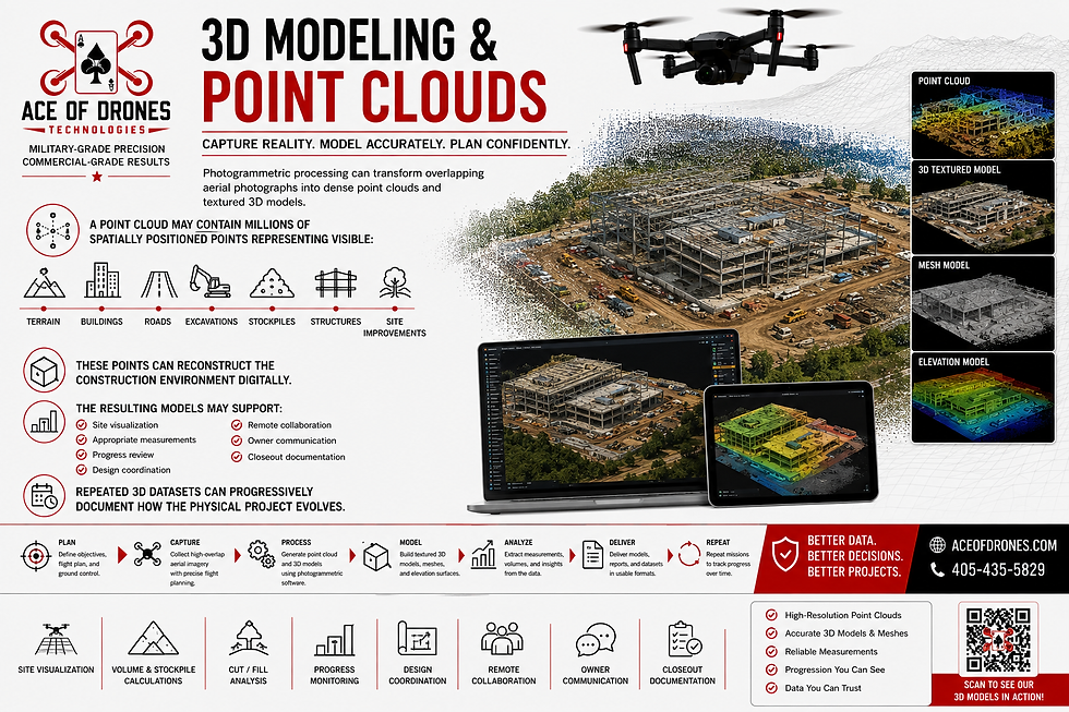
A point cloud may contain millions of spatially positioned points representing visible:
Terrain
Buildings
Roads
Excavations
Stockpiles
Structures
Site improvements
These points can reconstruct the construction environment digitally.
The resulting models may support site visualization, appropriate measurements, progress review, design coordination, remote collaboration, owner communication, and closeout documentation.
Repeated 3D datasets can progressively document how the physical project evolves.
BIM + UAS: Connecting Design Intent to Field Reality
BIM represents design intent.
UAS reality capture represents observable field conditions.
Connecting the two can create a powerful model-to-reality workflow.

UAS-derived information may support:
As-built verification
Model-to-reality comparison
Progress tracking
Clash investigation
Quantity validation
4D visualization
Subcontractor accountability
Digital Twin development
Closeout documentation
When georeferenced point clouds, orthomosaics, and 3D models are appropriately aligned with project information, qualified professionals can investigate how observable field conditions compare with design intent.
Repeated captures can also support schedule-based visualization by associating physical construction progress with time.
The objective is to connect:
DESIGN INTENT → FIELD REALITY → COMPLETED ASSET
Digital Twins and Long-Term Asset Information
The value of UAS data does not necessarily end when construction is complete.
When reality-capture information is systematically collected throughout construction and appropriately integrated with BIM, asset records, schedules, inspection information, and other project data, it can contribute to a richer digital representation of the completed facility.

Potential long-term uses may include:
Facility management
Maintenance planning
Future renovations
Roof and façade inspections
Asset documentation
Condition monitoring
Capital planning
Historical reference
This transforms the construction UAS program from a temporary documentation service into part of the project's broader information lifecycle.
Integrating Drone Data Into Existing Construction Workflows
Drone data provides greater value when it integrates into the systems the construction team already uses.

Depending on client requirements, UAS deliverables may support:
BIM
CAD
GIS
Common Data Environments
Project-management systems
Scheduling platforms
Cost-control systems
Quantity-tracking workflows
Reality-capture platforms
Asset-management systems
Before the first mission, the project team and UAS provider should establish:
What information is required?
Who will use it?
What decisions will it support?
What accuracy is required?
What coordinate system applies?
Which software will receive it?
Which file formats are needed?
How often should data be collected?
How should revisions be managed?
Who is responsible for incorporating updates?
The objective should not be to create another isolated folder of drone files.
Don't make the construction team adapt to the drone data. Design the drone-data workflow to support the construction team.
Data Organization and Reporting
Raw imagery is only the beginning.

A professional construction UAS data package may include:
Project summary
Flight information
Mission methodology
Aircraft information
Sensor information
Coordinate-system documentation
Ground-control information
Accuracy assessments
Orthomosaics
Point clouds
Elevation models
3D models
Volume calculations
Cut-and-fill reports
Progress comparisons
Inspection imagery
Annotated findings
Change-detection products
Data indexes
Professional reports
A professional dataset should allow another stakeholder to determine:
What was collected?
When was it collected?
Where was it collected?
How was it collected?
Which aircraft and sensor were used?
What coordinate system applies?
What accuracy was required?
How was the data processed?
What changed since the previous mission?
Which files are the final deliverables?
Consistent file naming, metadata, version control, mission identifiers, coordinate documentation, and report organization become especially important when a project is captured repeatedly.
This is the difference between delivering a folder full of photographs and delivering a professional construction dataset.
Data Ownership, Security, and Chain of Custody
Construction datasets can contain commercially sensitive information about project layouts, infrastructure, equipment, operations, progress, security, and access.

A professional data-management program should address:
Data ownership
Access permissions
Original-image retention
Processed-data retention
Version control
Storage
Backup
Metadata preservation
Confidentiality
Secure delivery
Chain of custody
Chain of custody becomes particularly important when information may later support claims, insurance matters, warranty questions, contractual disagreements, payment applications, change orders, or legal proceedings.
Maintaining original files, timestamps, metadata, processing records, and controlled deliverables can help preserve the integrity of the project record.
Professional data deserves professional stewardship.
FAA Compliance and Jobsite Coordination
Construction sites are complex operating environments.
Cranes, heavy equipment, temporary structures, personnel, roadways, changing access conditions, and other hazards must be considered when planning a mission.

Professional construction UAS operations should address:
FAA Part 107 requirements
Airspace review
Required airspace authorizations
Pre-flight planning
Weather conditions
Site-hazard assessments
Aircraft inspections
Visual line of sight
Launch and recovery areas
Crane coordination
Equipment operations
Personnel activity
Emergency procedures
Post-flight documentation
Projects may also be located near airports, heliports, hospitals, controlled airspace, or other locations requiring additional aviation planning.
Professional UAS operations therefore require both technical expertise and aviation discipline.
The safest and most useful UAS mission is one that is integrated into project operations rather than treated as an unrelated activity occurring above the site.
Repeatable Construction Workflows
Repeatability is one of the most valuable characteristics of a professional construction UAS program.
A project may initially require only a single orthomosaic, stockpile calculation, inspection, or progress flight.

Long-term value increases when the site is captured consistently using similar:
Flight routes
Altitudes
Camera settings
Coordinate systems
Ground-control methodology
Processing methods
File naming
Reporting standards
Deliverable formats
A project record might develop as:
BASELINE → WEEKLY/MONTHLY CAPTURES → MAJOR MILESTONES → SUBSTANTIAL COMPLETION → FINAL CLOSEOUT
When collection and processing remain consistent, datasets captured months apart become much easier to compare.
A project manager can move backward through the site's history. An owner can review how development evolved. An engineer can investigate earlier conditions. A superintendent can revisit work that is no longer visible.
One flight creates a deliverable.
A repeatable UAS program creates a digital historical record.
Who Benefits From Construction UAS/Drone Data?

General Contractors
General contractors can use UAS information to improve project visibility, progress documentation, quantity monitoring, site logistics, subcontractor coordination, and owner communication.
Project Managers
Project managers can use visual and quantitative information to support planning, reporting, scheduling, coordination, quantity discussions, and decision-making.
Superintendents
Superintendents can gain a broader perspective of access, staging, congestion, equipment placement, material storage, temporary facilities, and changing field conditions.
Civil Engineers
Civil engineers can use appropriately specified geospatial information to support terrain, grading, drainage, infrastructure, and site-development workflows.
Developers and Owners
Owners and developers can gain a clear visual understanding of project progress without relying exclusively on site visits and narrative reports.
Survey and Engineering Teams
Professional surveyors and engineers can incorporate appropriately specified UAS datasets into compatible geospatial workflows while retaining responsibility for work requiring licensed professional judgment.
Safety and Quality Teams
Aerial information can provide additional visibility into difficult or elevated areas and support broader site-condition and quality-control assessments.
Lenders and Investors
Consistent aerial documentation can complement draw packages, progress reports, executive summaries, and other project-control information.
Turning Construction Activity Into Construction Intelligence
Each UAS capability is valuable independently, but the real power of the technology emerges when those capabilities are combined.

A drone can map the site before construction begins.
It can document earthwork as the ground changes.
It can measure stockpiles as materials move.
It can record utilities before they disappear below grade.
It can document foundations before they are covered.
It can monitor progress as structures rise.
It can inspect difficult-to-access areas.
It can create point clouds and 3D models.
It can provide information for BIM and model-to-reality workflows.
It can document final site conditions.
When those missions are collected systematically, processed consistently, organized professionally, and retained throughout the project, they create something much more valuable than a collection of aerial photographs.
They create a repeatable digital record of the construction project.
The drone is the collection platform.
The data is the product.
The information gained from that data is the value.
Better Data. Better Decisions. Better Construction Outcomes.
Construction does not need drones simply because drones are new technology.
Construction needs better information.
Information that is current
Information that is measurable.
Information that can be compared.
Information that can be shared.
Information that can be integrated.
Information that can be retrieved when it matters.
Information that helps you make better decisions.
When collected correctly and integrated into project workflows, professional UAS data can help construction teams:
Plan smarter
Measure more effectively
Document consistently
Identify issues earlier
Communicate more clearly
Reduce unnecessary risk
Track progress objectively
Preserve project history
Improve stakeholder visibility
Make better-informed decisions
Build with greater confidence
At Ace of Drones, we do not consider the drone itself to be the deliverable.
The data is the deliverable.
The aircraft is the tool used to collect it.
Our objective is to transform aerial information into accurate, organized, repeatable, actionable construction intelligence.
Every mission should answer a project question.
Every dataset should have a purpose.
Every deliverable should make it easier for construction professionals to understand their project and make informed decisions.
Why Partner With Ace of Drones?
Choosing a construction drone provider should involve much more than comparing aircraft specifications.
The aircraft is only the collection platform.

Professional construction UAS work requires an understanding of:
Aviation
Operational safety
GNSS positioning
RTK/PPK workflows
Mapping
Photogrammetry
Geospatial accuracy
Construction sequencing
Reality capture
Project documentation
Data management
Reporting
BIM/CAD/GIS integration
Client workflows
Intended use of the final data
A beautiful aerial photograph that cannot answer a project question has limited value.
A detailed 3D model with unknown accuracy has limited value.
A technically excellent dataset that cannot integrate into the client's workflow has limited value.
Ace of Drones approaches the mission from the opposite direction.
We begin by asking about requirements:
What does the client need to know?
What decision will the information support?
What deliverable will answer that question?
What level of accuracy does that deliverable require?
What collection methodology will produce it?
How should the information be organized so the client can use it effectively?
Only after those questions are answered should the aircraft take off.
That is the difference between drone photography and professional UAS data collection and analysis.
Ready to Put UAS Data to Work on Your Construction Project?
Contact Ace of Drones for professional UAS/Drone Data Collection and Analysis in the Construction Industry.

Ace of Drones Technologies
MILITARY-GRADE PRECISION - COMMERCIAL-GRADE RESULTS
405-435-5829


Comments